|
|||
|
Features: The Stevens Trail is one of the most scenic and
accessible trails in our area. Originally built as a toll road for pack mules
between Colfax and the gold fields of Iowa Hill, Part way down the trail divides: The upper route is strictly for hikers, leading to a creek crossing amid a series of waterfalls. It continues back down and rejoins the lower route, marked for bikers and equestrians. Availability: Stevens Trail is one of the most popular trails in the area. (Every year or so it is "rediscovered" in a Sacramento Bee feature article.) Managed by BLM, the trail is open all year. It is well groomed and wide enough for multi-use from the trailhead down to where it passes an old mine entrance, about 1.5 miles. After that the trail becomes very narrow and is not recommended for horses unless both horse and rider are thoroughly experienced with such trails. Difficulty: The Stevens Trail is about 7.2 miles out and
back. From the trailhead at 2400ft., the trail drops gradually but steadily to
the river at about 1200ft. Footing is good to excellent, but the trail is
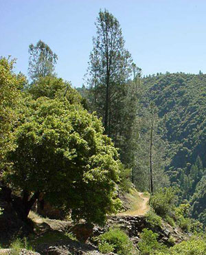
narrow in places and the drop-offs are a little scary. Cautions:
|
|||
|
Directions to trailhead: The Stevens Trail starts at the
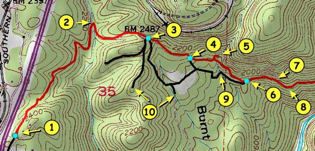
Trailhead Parking: Large paved parking lot with signage Trail Description: The first two miles of the trail are detailed on this map. The clickable numbers refer to the notes that follow. |
|||

|
|||
| Map Notes: | |||
| 1) Trailhead parking area. | |||
| 2) After 3/4 mi. of gentle multi-use downgrade, Trail crosses a small creek. Turn right at the trail marker on the other side and then follow the graded road uphill for about 1/4 mile to where it crosses a saddleback. | |||
| 3) Just beyond where the road starts downhill, Stevens Trail leaves the graded road to the left. Look for a metal post with the word "trail" and an arrow pointing left. The graded road continues 1/4 mile downhill to the Burnt Flat area, but the road south is blocked by a plowed berm and a chain where it enters private property (see note 10). | |||
| 4) The trail forks here, marked by a signpost. Hikers may use either trail, but bikers and equestrians must take the right hand (lower) route. The left hand route includes some steep stepdown sections among bolders near the creek waterfalls. Directly above, but out of view, is Cape Horn, a horseshoe curve of active railroad track supported in places by limestone block masonry constructed by Chinese workmen in the 1860's as part of the original transcontinental railroad. | |||
| 5) There is a short side trail on the north side of the walking route that leads directly to the main falls. | |||
| 6) The two routes rejoin here, and the trail continues east across an open shale slide area. | |||
| 7) Location of abandoned hard rock mine. If you are riding a horse, this is a good place to turn around if your horse is not experienced with narrow trails. The mine tunnel goes straight back into the mountainside and out of sight into darkness. Do not risk injury by entering the tunnel. The excavation is said to drop downward without warning. | |||
8) Location of the narrow
trail section that skirts the near vertical face of the rocky mountain face.
Yes, it's scary, but the view of the canyon is spectacular.
The single track trail continues to follow the contours of the canyon for about two more miles, ending at Secret Ravine, an excellent picnic spot with a sandy beach. |
|||
| 9) The lower trail makes its creek crossing here. The crossing is over wide, flat rocks with deep gaps. The footing is safe for hikers, but anyone with horses should lead them through with great care. | |||
| 10) The old trail known as Burnt Flat Loop is currently blocked and posted out by a private landowner at the locations indicated. Burnt Flat is an undeveloped natural meadow area about 500ft above the river that looks today very much as it did in the 1860's. | |||
|
MVTA tries to assure the accuracy of
the trails information presented, Email your comments or questions to our Trails Coordinator. |
| Copyright © 2022 by Meadow Vista Trails Association. All Rights Reserved. |


