Keeping our Trails List simple and useful
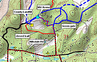
Sample of a Web of Trails |
The trails in our area are numerous. Many are the
heritage of the 1850's, when gold prospectors swarmed the American River
canyons and built foot paths and wagon roads. Collectively, the trails within
just a ten-mile radius of Meadow Vista total well over 100 miles.
Describing these trails for the public in a
simple and useful way is our goal. But in many areas they form a web of
interconnections. Inventorying them as if they were simple and distinct trails,
each with its own trailhead and each running from "A to B," is not an adequate
strategy.
Our approach is to identify and map local trails
in full detail, summarizing afterward to produce the trail
descriptions more easily used by our members and the public. The components
of the process are these:
- When possible, we use GPS tracking to plot each
section of a trail, intersections, trail heads, landmarks and so on.
- We use interactive topographic mapping software to
visualize and refine the GPS tracking info.
- Trails that have been collected into our inventory
include some that are not open for general use. Some may require improvement,
such as brush work or signage, before being offered to the public. Others may
be closed due to private property restrictions.
MVTA Public Trails List.
Full information about our trails that are
considered open to the public is provided here on the
MVTA website. Trails that have been vetted through our database are listed,
described and mapped in a format that encourages public use.
Trails on our public list are described in terms
of noteworthy features (scenery, vegetation, historic value, etc.), types of
allowed use, difficulty, cautions, directions to trailhead, parking, trail
directions, map and elevation profile.
MVTA is one of many trail organizations in the
Sierra Foothills. Our trail mapping effort includes the community of Meadow
Vista, but extends (as does our membership) to cover the neighboring Placer
County communities of Applegate, Auburn, Bowman, Christian Valley, Colfax and
Weimar. Refer to our Links page for local, regional and
national trail-related organizations.
Trail Inventory Uses
The MVTA Mission Statement commits our organization
"to maintaining and establishing safe walking, running, biking and equestrian
trails." Fundamental to carrying out this mission is our ability to
identify the numerous existing trails in our area and to document their status.
Our trail inventory allows us to focus our efforts to promote public trail use,
target trail maintenance efforts, and defend trails from unwarranted
closure.
In addition to supporting our primary mission, our
trails inventory has wider uses:
- Placer County Search and Rescue. MVTA trail
information is available on request to search teams.
- CalFire and local forest fire response teams.
Trail information can be vital for ground crews that need to reach canyon
wildfire locations quickly.
- Placer County Planning. MVTA has a cooperative
agreement with Placer County to assist in identifying trails in our area. The
County uses trail location data, overlaid on its computerized property maps, to
assist communities in developing their respective Community Growth Plans.
- Other Trail Organizations. MVTA trails
potentially connect with those of surrounding trail organizations. As these
connections are located and documented as public trails, appropriate links are
added to this website.
|
|
MVTA tries to assure the
accuracy of the trails information presented,
but can make no claims to
such. Please let us know if any entries are incorrect.
Email your comments or
questions to our
Trails
Coordinator. |
|