|
Where did the name come from?
Heather Glen is the name of a local unincorporated area
that is uphill of this trail. The trail used to originate in that area, but due
to security concerns has been closed to public access from that direction by a
property owner.
The remainder of trail is still called Heather Glen Trail but
does not connect to its namesake.
Features:
This trail begins where the Assassin's
Trail leaves off and continues northeast, following the western slope of
the American River's North Fork a few hundred feet below the ridgeline. The
trail then drops from one old mining road to another until picking up one that
decends with an easy grade into the canyon of the North Fork. The trail ends at
a bend of the river where the water is reliably deep enough for swimming.
Depending on the prior Spring's runoff, there will either be a wide sandy beach
or else a wide field of river rock to cross to reach the
river.
Availability:
Heather Glen Trail is multi-use and is sometimes used by dirt
bikes and ATVs, but remains in good condition. To avoid causing erosion, steep
sections of this and adjoining trails should not be used during the rainy
season (usually mid-November thru mid-April.)
Trailcourse and Difficulty:
The first section of this trail, from where it leaves
the loop at the end of the Assassin's Trail, is an old wagon road that follows
the contours of the canyon with only gradual changes of elevation. This section
of the route is easy to hike or ride. The footing is even and mostly free of
rocks.
Next, it is necessary to connect with the main wagon road
to the river.Use of either of two single-track trails (each turns downhill
to the right) which are steep in places. These single-track sections rejoin
along an old wagon road. Look for a short single-track connection to yet
another wagon grade. It makes a switchback after about 200 yds and then joins
the main wagon road after another 100 yards. From this junction, the main wagon
road makes an "S" turn at this point. At the bottom of the S there is another
junction (to the left) with the Grubb Mine Trail. Follow the main wagon road to
the right. From there, it is easy going down hill for almost all of the
remaining descent into the canyon.
The final 1/4 mile before reaching Codfish Creek is very
steep and the footing is very uneven. Hikers should use a walking stick in
this section; equestrians should dismount and lead their horses down. Mountain
bikers will, of course, be in their element!
Map Notes:
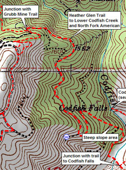
Click on the map above to view a detailed version. The
Heather Glen Trail has various connections with other trails that are
separately described: Esoteric Society Trails;
Assassin's Trail; Grubb Mine
Trail; and the
Ponderosa
Bridge to Codfish Falls foot trail.
Trailhead:
Due to the closure to the public of the graded/wagon
road leading down from the Heather Glen area, the trail no longer has its own
trailhead.
MVTA members who have their own key to the Esoteric
Society property, are able to exit the back gate next to the parking area and
follow the Assassin's Trail to the northeast for a few hundred yards and pick
up the Heather Geln trail there.
Otherwise, the closest trailhead is at Cerro Vista
Road. You will need to traverse the length of the Assassin's Trail before
joining the Heather Glen Trail. As an alternative, you can take the
Vore Mine Trail out of Sun Valley and then cross
Codfish Creek and take the Grubb Mine Trail to reach the Heather Glen
Trail.
Cautions:
 This trail traverses
Cougar Habitat. Cougar sightings are rare,
but use good sense: Do not walk or ride this trail alone. Keep small
children and pets close at hand. This trail traverses
Cougar Habitat. Cougar sightings are rare,
but use good sense: Do not walk or ride this trail alone. Keep small
children and pets close at hand.
Poison Oak grows along
much of this trail and hangs out into the trail in places.
Drinking Water must be carried with you. Creek and
river water are not safe for human
consumption, no matter how clean it looks. Drink it only in an emergency
and consult a doctor afterwards. |

