Special Note:
Trailhead parking for Upper Clementine Trail, is
located on private land along the ridgeline, adjacent to Cerro Vista road.
The access trail leading from this parking area to the
trailhead are OFF LIMITS to motorized off-road vehicles (OHV's.) Large
warning signs, gates, posts and concrete barriers are in place to discourage
prohibited users ONLY. Walkers, equestrians and mountain bikers are welcome
to use the trails. The Placer County Sheriff's Office is aware of the
restrictions and will respond to reports of illegal use.
Recreational use of this trail, as with all others
listed on this website, is at the user's own risk. If you encounter anyone who
claims you are trespassing or suggests you should not use the trail, or if you
encounter any OHV users, please report the incident at once to the
MVTA Trails
Coordinator.
Map Notes:
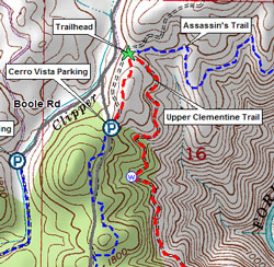
Click on map shown to view the full-size version. Access to
Boole Road is from the Applegate exit from I-80, top left. The trailhead is
marked by a green star. The best parking location is shown as a circle-P icon
to the south of the trailhead, next to Cerro Vista Road. (Do not use the
parking area at the end of Boole Road. It is on private property and the old
unpaved section of Boole Road is gated closed.)
Features:
This trail decends into the North Fork canyon of the American
River. It is one of the most beautiful in the region and also the easiest to
access. Views from the trail take in breathtaking vistas of the wild and scenic
river hundreds of feet below.
Availability:
During the rainy season (usually mid-November thru mid-April)
this and adjoining trails should be used by hikers only to avoid causing
erosion.
Difficulty:
The trail covers about 2.5 miles in all, 5 miles round trip.
The route is generally easy to hike or ride. The footing is even and mostly
free of rocks and keeps a gentle, constant slope as it drops about 1,150 feet
to the river. The grade becomes more steep in the last half-mile before ending
on the wide sandy beach.
Cautions:
 This trail traverses
Cougar Habitat. Cougar sightings are rare,
but use good sense: Do not walk or ride this trail alone. Keep small
children and pets close at hand. This trail traverses
Cougar Habitat. Cougar sightings are rare,
but use good sense: Do not walk or ride this trail alone. Keep small
children and pets close at hand.
Poison Oak grows along
much of this trail and hangs out into the trail in places.
Drinking Water must be carried with you. Trailside and
river water are not safe for human
consumption, no matter how clean it looks. Drink it only in an emergency
and consult a doctor afterwards.
Directions to trailhead parking:
The trailhead is located on a saddleback that is only
about 300 ft from the side of Boole Road, but there is no parking at the
trailhead itself. The closest parking is about 1/4 mile away on Cerro Vista
Road.
- From I-80, take the Applegate exit and follow the
overpass road East to where it T's into Applegate Road.
- Go left onto Applegate Road; the road passes through
a one-lane tunnel under the railroad.
- Take an immediate right after the tunnel onto Boole
Road. Boole Road is narrow and has poor shoulders, so drive with care. There is
a dirt access road to the trailhead about 1.5 miles along this road, on your
left. There is no signage, so don't be surprised if you miss it. Again,
parking at the trailhead itself is not available: The short dirt road to
the trailhead, about 300 ft. away, is barricaded to prevent entry by
OHV's.
- Go left at the fork onto Cerro Vista Road. About 200
yds up the hill is a flat dirt area on your left. There is room for several
cars or horse trailers in the flat area. From here, you can reach the trailhead
by taking the graded road to the north that follows the ridgeline.
Trailhead Location:
The trailhead itself is at a saddleback on the ridgeline. Click
on the map above for a more detailed version, where the trailhead is marked by
a green star.
From the Cerro Vista Road parking area, follow the dirt roadway
north, up and over the hill and down to the saddleback area, about 1/4 mile.
There is presently no trail signage at the trailhead, so here is
what to look for: From the saddleback, there are trails leading away in five
directions:
- South: This is the trail you arrived on, coming from
the Cerro Vista Road parking area, 1/4 mile away.
- East: The well-graded road that heads downhill is the
Upper Clementine Trail.
- Northeast: This single-track trail, sometimes partly
obscured by brush, is the Assassin's Trail.
- West: A short dirt road connects to Boole Road about
300 ft away. There is room for parking for one passenger vehicle off pavement,
but it is not recommended.
- North: A wide dirt fire road climbs steeply uphill and
continues along the ridge to where It is joined by the Assassin's Trail
route.
Trail Course:
Just off the trailhead, there is a heavy locked gate to prevent
entry by motorized traffic other than BLM and firefighting vehicles. Walkers,
trailbike riders and equestrians are permitted to skirt the gate on one side.
This trail decends from the saddleback area and follows a fire access road down
into the canyon, ending on a wide sandy beach just upstream from Lake
Clementine. It is a graded road for the first half but becomes more of a wagon
road farther down.
Follow the graded roadway for about two miles. Part way,
there is a natural year-round spring on the uphill side of the trail, denoted
on the map by the circle-w symbol. The water is suitable for pets and stock
animals only.
You will come to a junction area where, in 2005, Parks
& Rec placed a number of Toyota-size cement blocks across the trail to
prevent vehicle traffic from reaching the river. The blocks are sometimes moved
aside, but they still serve well as a junction marker.
- The Main Trail angles off downhill to your left.
- Straight ahead is a foot trail that leads out to a
beautiful viewpoint at the end of Long Point -- well worth the side trip. Bring
your camera.
- To your right is a wide trail that slowly decends for
about a mile toward upper Lake Clementine, passing an old mining claim with its
brick furnace building largely intact.
- Behind you, back up the trail several yards, is the
turnoff to the Training Hill trail.
From the junction area, the Upper Clementine Trail
becomes more like the Gold Rush wagon road that it originally was: somewhat
steeper, but still fairly easy going. It rounds the end of Long Point and
continues its decent to the river level. It narrows to single track in one
place, about 1/4 mile from the river, where past efforts to discourage 4WD
traffic have caved away the downhill shoulder. It then comes out onto the wide
sandy edge of the North Fork of the American River.
The river forms a large slow pool in this area that is generally
safe for swimming. At the downstream end of the pool the river enters a section
of mild, but stoney rapids before reaching the upper end of Lake Clementine.
Across the river is the Upper Clementine picnic area, which is
accessible by vehicle from Foresthill
Road.
Extended Route:
You can ford the river (conditions permitting) just above where
the rapids begin. Use caution in crossing the river, especially during
the period of Spring runoff. (Allow for the possibility that the water may be
too deep and swift to cross safely.)
Continue up the graded access road on the other side for about
1.5 miles to the Foresthill Divide Road at the top.
The Foresthill Divide Loop Trail is a
ten-mile multi-use trail that crosses the access road shortly before it reaches
the highway. At the far end of the trail loop, it passes through the Drivers Flat trailhead area, which offers
access to the Middle Fork of the American River and the
Western States Trail.
|

