|
||||||
|
Due to the popularity of Hidden Falls, parking reservations are required on weekends and other high use days. If you plan to visit on an affected day, please go to the Park's Parking Reservation web page to purchase a pass. Parking Reservations are NOT issued at the site.
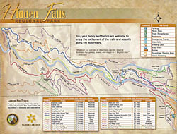
Features: Hidden Falls offers a variety of trail environments, ranging from open grasslands near the parking area to riparian creeksides to oak forested hillsides above the creeks. In addition, there are creek waterfalls and cascades, some viewable from specially-constructed viewing decks. Bring your camera! Availability: Trails are multi-use, suitable for walkers,
cyclists and equestrians.
Difficulty: Trails are generally rated Easy to hike or ride, although some are rated Moderate or even Difficult. Consult the trail list included with the map. Footing is even and mostly free of rocks. Trails rated as more difficult are generally also more narrow. All wildlife in the park is protected. Western Pond Turtles inhabit the creek areas, along with Salmon and the Western Toad. You may see a variety of birdlife, such as California Quail, Western Meadowlark, red-tailed hawks, red-shouldered hawks, golden eagles, wild turkeys and woodpeckers. Mammals such as deer, coyotes, bobcats, racoons and rabbits may be seen. Plantlife, in addition to Buckeye and a variety of oak trees, includes California Poppies, Lupine and Globe Lillies.
Cautions:
|
||||||
|
MVTA tries to assure the accuracy of
the trails information presented, Email your comments or questions to our Trails Coordinator. |

&imagename=images/hiddenfalls/hiddenfallsbrochure-front.jpg)
&imagename=images/hiddenfalls/hiddenfallsbrochure-back.jpg)
| Copyright © 2022 by Meadow Vista Trails Association. All Rights Reserved. |